ALCES

A Landscape Cumulative Effects Simulator. ALCES simulates past and future landscape change across large regions, and maps how ecological and cultural values respond to it. It is developed and delivered by Integral Ecology Group.
An animated map of an Alberta watershed from 1900 to the present, in which roads, well sites, cutblocks and settlement spread steadily across the landscape.
Reconstruction of change in cumulative development footprint over the past century in an Alberta watershed. Prepared using ALCES Flow.

Cumulative effects

The risk is gradual, and no single project shows it

Cumulative effects refer to changes in the environment caused by the accumulation of activities across space and time. Too often, decisions about future development focuses on individual projects and fails to identify the risk of gradual change caused by multiple development activities. The implication is that cumulative effects can lead to environmental and cultural degradation despite a rigorous, project-based impact assessment process. Cumulative effects assessment is intended to address this shortcoming by evaluating the combined effects of activities as opposed to focusing on any single activity or project.

To be effective, cumulative effects assessment needs to consider impacts across large regions and time frames. The full set of influential drivers of ecosystem change need to be addressed, which often includes multiple types of industrial development (e.g., forestry, agriculture, mining, energy), settlements, infrastructure (roads, transmission corridors), natural disturbances such as fire, and climate change. And assessment of outcomes needs to be comprehensive by evaluating impacts to a range of ecological and cultural values.

The platform

Simulation, without needing to be a modeller

Comprehensive cumulative effects assessment is challenging due to the need to track the combined impacts of multiple activities. Computer modelling is well suited to this task, providing a way to simulate and map change across large regions and long timeframes. ALCES is designed to facilitate cumulative effects assessment by making simulation of development and its impacts accessible without requiring a computer modelling background. To achieve this, ALCES tools are pre-populated with data and models so that users can efficiently map impacts to assess consequences of proposed developments and evaluate mitigation options.

At the core of ALCES is a powerful landscape simulator that models changes in land cover, footprint, and forest age across your region. This simulator drives calculations of a wide range of ecosystem indicators that are related to landscape composition such as intact landscapes, wildlife habitat, and opportunities for Indigenous land use—giving you a comprehensive picture of the ecological and cultural impacts of different scenarios.

20+ years
of cumulative effects assessments and land-use planning across Canada
2,000 – 500,000+ km²
the range of regions ALCES has been applied to
~30 m
the resolution the landscape is reconstructed at
matching most satellite-derived data products
20 – 120 min
for a simulation to process, once launched
varies widely with region size, complexity, and whether similar analyses have been run before

What ALCES is for

IEG delivers ALCES to increase capacity for holistic ecosystem and community impact assessment through:

Simulating change

Simulating past and future landscape and population dynamics across large regions.

Mapping response

Mapping ecosystem responses to land use and climate change.

Indigenous knowledge

Incorporating Indigenous community knowledge.

Tools that outlast the report

Providing user-friendly tools for ongoing post-project assessment.

Two kinds of landscape twin

Which one a project uses follows from whether the question is about the past or the future.

Discrete

The landscape as it is

Discrete twins model the present-day landscape as accurately as possible by integrating disturbance, footprint, land cover, and forest data from diverse sources into exact per-pixel values at fine resolution. Because they are built from real historical data, they are sometimes referred to as historical analysis.

Distribution

The landscape as it might become

Distribution twins model key variables as distributions within each coarse-resolution pixel, producing expected values after accounting for projected landscape dynamics. This probabilistic representation is well suited to forecasting, where outcomes are inherently uncertain.

What gets measured

Indicator calculations are the ultimate output of the platform. They are configured per project, and vary by jurisdiction and region across Canada.

Ecological

Habitat suitability (moose, fisher, caribou, cranberry), fish stream crossings, forest age distribution, rates of disturbance.

Indigenous land use

Calculations of opportunity for Indigenous peoples to practice traditional land uses such as moose hunting, gathering, trapping, and camping.

Access and disturbance

Land-use accessibility, and cumulative disturbance footprint.

Population dynamics

With ALCES PopDyn, landscape and population simulations are integrated to assess the consequences of development, climate change, harvest, and interspecies interactions to wildlife and fish populations.

How an assessment usually works

We build each site around the questions its organization needs to answer, so no two are alike. The most common workflow compares a development scenario to a baseline.
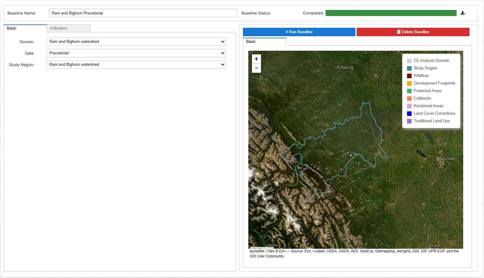
Three screens from the ALCES web tools: selecting a study region on a satellite map, configuring a development scenario, and comparing a habitat indicator between a baseline and a scenario in the results viewer.

Establish a baseline

A baseline is a picture of your landscape at one moment in time, and it is what everything else is measured against. The date of the baseline is an important consideration. A present-day baseline limits the ability to assess cumulative effects because impacts are assessed relative to what is often an already disturbed present-day state. A precolonial baseline supports holistic cumulative effects assessment by evaluating the combined impacts of existing and potential future development.

Three screens from the ALCES web tools: selecting a study region on a satellite map, configuring a development scenario, and comparing a habitat indicator between a baseline and a scenario in the results viewer.

Add a scenario

ALCES is capable of running two types of forecast scenarios: project and long-term. Project scenarios add one or more proposed projects to the present-day landscape and recalculate the indicators to assess the cumulative effect of existing and future development. Long-term scenarios simulate uncertain future developments and fire using probabilistic rules, and are useful for land-use planning and strategic regional assessment.

Three screens from the ALCES web tools: selecting a study region on a satellite map, configuring a development scenario, and comparing a habitat indicator between a baseline and a scenario in the results viewer.

Compare

The impact of a development scenario can be assessed by comparing outcomes to a baseline. Greater departure from the baseline implies greater risk to the indicator.

A different question, a different workflow

A baseline is one moment in time. A historical analysis is a series of timesteps showing how your indicators arrived at their current condition. A historical analysis, also referred to as a backcast, is useful for illustrating how impacts have accumulated through time. The strategic perspective provided by a historical analysis helps to convey the limited capacity for project-by-project impact assessment to address cumulative effects — and therefore the importance of managing development holistically. Importantly, historical analysis can also be useful assessing infringement of Indigenous rights.

Published work

Much of our work is confidential to the clients who commission it. These are selected papers and public reports, spanning two decades of assessments, that we are able to discuss publicly.
  1. Antwi, E. K., Rempel, R. S., Carlson, M., Darko, A. N., & Yohuno (Apronti), P. T. (2026). An assessment of mitigation strategies for maintaining a balanced moose-wolf-caribou system in Ontario’s ring of fire region. Frontiers in Forests and Global Change, 9.
  2. Carlson, M., Straker, J., Berg, K., Bockstael, E., Borle, E., Bindle, L., Belisle, C., Bonnyman, M., Faichney, F., & Golden, D. (2025). Bringing Together Indigenous Knowledge and Simulation Modelling to Assess Cumulative Impacts to Indigenous Land Use in Northeastern Alberta, Canada. Environmental Management, 75(11), 2960–2976.
  3. Heim, N., MacDonald, R., Horsethief, C., Luke, C., Proctor, M., Machmer, M., Birdstone, V., Warden, R., Wullum, C., Plewes, R., Chernos, M., & Carlson, M. (2025). The Wolverine Project: Evaluating Cumulative Effects Within the Land of Ktunaxa Using the One Heart Method. Environmental Management, 75(11), 2931–2946.
  4. Lin, H.-Y., Ryan, M., Camfield, A., Carlson, M., Carrière, M.-A., Raymond, C., & Naujokaitis-Lewis, I. (2025). Using climate change metrics to inform conservation of Canada’s Priority Places for Species at Risk. FACETS, 10, 1–16.
  5. Antwi, E. K., Rempel, R. S., Carlson, M., Boakye-Danquah, J., Winder, R., Dabros, A., Owusu-Banahene, W., Berryman, E., & Eddy, I. (2023). A modelling approach to inform regional cumulative effects assessment in northern Ontario. Frontiers in Environmental Science, 11.
  6. Carlson, M. (2022). Grizzly Bear Movement and Conflict Risk in the Bow Valley: A Cumulative Effects Model. Yellowstone to Yukon Conservation Initiative.
  7. Carlson, M., Young, H., Linnard, A., & Ryan, M. (2022). Supplementing Environmental Assessments with Cumulative Effects Scenario Modeling for Grizzly Bear Connectivity in the Bow Valley, Alberta, Canada. Environmental Management, 70(6), 1066–1077.
  8. Rempel, R. S., Carlson, M., Rodgers, A. R., Shuter, J. L., Farrell, C. E., Cairns, D., Stelfox, B., Hunt, L. M., Mackereth, R. W., & Jackson, J. M. (2021). Modeling Cumulative Effects of Climate and Development on Moose, Wolf, and Caribou Populations. The Journal of Wildlife Management, 85(7), 1355–1376.
  9. Leston, L., Bayne, E., Dzus, E., Sólymos, P., Moore, T., Andison, D., Cheyne, D., & Carlson, M. (2020). Quantifying Long-Term Bird Population Responses to Simulated Harvest Plans and Cumulative Effects of Disturbance. Frontiers in Ecology and Evolution, 8.
  10. Carlson, M., Browne, D., & Callaghan, C. (2019). Application of land-use simulation to protected area selection for efficient avoidance of biodiversity loss in Canada’s western boreal region. Land Use Policy, 82, 821–831.
  11. Adamczewski, J. Z., Carlson, M. J., Daniel, C. J., Gunn, A., Johnson, C. J., Nishi, J. S., Russell, D. E., Stelfox, J. B., & Taylor, D. (2016). Development of Modeling Tools to Address Cumulative Effects on the Summer Range of the Bathurst Caribou Herd: A Demonstration Project. Environment and Natural Resources, Government of the Northwest Territories, File Report 148.
  12. Carlson, M., Quinn, M., & Stelfox, J. B. (2015). Exploring Cumulative Effects of Regional Urban Growth Strategies: A Planning Scenario Case Study from the Calgary Region of Western Canada. ISOCARP Review, 11.

Try it

The same demonstration tool, preconfigured for a region in each jurisdiction, with landscape data and indicators already loaded. Pick the one closest to your region.

Try ALCES, or talk to us about your region

The demonstration sites above are open to anyone with an account, and an account takes a minute to create. If you would prefer to be shown the platform, or would like to discuss a site configured for your own region, data and indicators, we would be glad to hear from you.